Tropical Storm Isaias Expected to hit the Berkshires Tomorrow Night
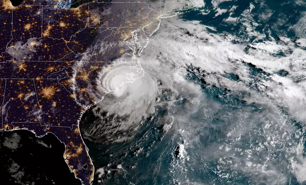
Isaias is expected to make landfall as a hurricane tonight in the Carolina's delivering strong winds and heavy rainfall. The storm is currently tracking towards the Berkshires and will impact tomorrow night according to the National Weather Service.
A Tropical Storm Warning is in effect as the hurricane is expected to lose intensity over landfall but will still deliver heavy rain and strong winds. Rainfall between 2 to 4 inches is expected with some localized areas receiving up to 6 inches. Wind guests could be as high as 50 mph tomorrow night.
Wind speeds of a tropical storm will range between 39 and 72 mph consistently for at least a one minute. A hurricane will deliver winds in excess of 74 mph for one minute or more.
A Tropical Storm Warning is now in effect. This warning coming from the National Weather Service… Equivalent Tropical Storm force wind
- Peak Wind Forecast: 30-40 mph with gusts to 50 mph
- Window for Tropical Storm force winds: Tuesday afternoon
until early Wednesday morning
- THREAT TO LIFE AND PROPERTY THAT INCLUDES TYPICAL FORECAST
UNCERTAINTY IN TRACK, SIZE AND INTENSITY: Potential for wind 58
to 73 mph
The wind threat has remained nearly steady from the
previous assessment.
- PLAN: Plan for dangerous wind of equivalent strong tropical
storm force.
- PREPARE: Remaining efforts to protect life and property
should be completed as soon as possible. Prepare for
significant wind damage.
- ACT: Move to safe shelter before the wind becomes hazardous.
- POTENTIAL IMPACTS: Significant
- Some damage to roofing and siding materials, along with
damage to porches, awnings, carports, and sheds. A few
buildings experiencing window, door, and garage door
failures. Mobile homes damaged, especially if unanchored.
Unsecured lightweight objects become dangerous projectiles.
- Several large trees snapped or uprooted, but with greater
numbers in places where trees are shallow rooted. Several
fences and roadway signs blown over.
- Some roads impassable from large debris, and more within
urban or heavily wooded places. A few bridges, causeways,
and access routes impassable.
- Scattered power and communications outages, but more
prevalent in areas with above ground lines.
* FLOODING RAIN
- LATEST LOCAL FORECAST: Flash Flood Watch is in effect
- Peak Rainfall Amounts: Additional 2-4 inches, with locally
up to 6 inches.
- THREAT TO LIFE AND PROPERTY THAT INCLUDES TYPICAL FORECAST
UNCERTAINTY IN TRACK, SIZE AND INTENSITY: Potential for
moderate flooding rain
- The flooding rain threat has remained nearly steady from
the previous assessment.
- PLAN: Emergency plans should include the potential for
moderate flooding from heavy rain. Evacuations and rescues
are possible.
- PREPARE: Consider protective actions if you are in an area
vulnerable to flooding.
- ACT: Heed any flood watches and warnings. Failure to take
action may result in serious injury or loss of life.
- POTENTIAL IMPACTS: Significant
- Moderate flooding may prompt several evacuations and
rescues.
- Rivers and tributaries may quickly become swollen with
swift currents and overflow their banks in a few places,
especially in usually vulnerable spots. Small streams,
creeks, canals and ditches overflow.
- Flood waters may enter some structures or weaken
foundations. Several places may experience rapid inundation
of underpasses, low-lying spots, and poor drainage areas.
Some streets and parking lots take on moving water as storm
drains and retention ponds overflow. Driving conditions
become hazardous. Some road and bridge closures.
A Flash Flood Watch in effect from 8:00 am tomorrow morning (Tuesday) until 8:00 am Wednesday.
This link will help you prepare for the storm.

LOOK: See Photos of the Year From the International Photography Awards
More From WUPE


